


Le Moussau-Ouchamps (variante)

leeho
Gebruiker
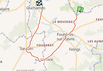

Lengte
12 km

Max. hoogte
122 m

Positief hoogteverschil
98 m
Km-Effort
13,3 km

Min. hoogte
78 m

Negatief hoogteverschil
96 m
Boucle
Neen
Datum van aanmaak :
2014-12-10 00:00:00.0
Laatste wijziging :
2014-12-10 00:00:00.0
45m
Moeilijkheid : Gemakkelijk

Gratisgps-wandelapplicatie
 SityTrail
IGN / Geografische instituten
SityTrail Plus
De wereld gaat voor u open
Over ons
Tocht Fiets van 12 km beschikbaar op Centre-Val de Loire, Loir-et-Cher, Le Controis-en-Sologne. Deze tocht wordt voorgesteld door leeho.
Beschrijving
Variante itinéraire 1
Plaatsbepaling
Land:
France
Regio :
Centre-Val de Loire
Departement/Provincie :
Loir-et-Cher
Gemeente :
Le Controis-en-Sologne
Locatie:
Fougères-sur-Bièvre
Vertrek:(Dec)
Vertrek:(UTM)
376110 ; 5258170 (31T) N.
Opmerkingen